![]()

Major Nebraska Rivers and Their Drainages
Part 2 – The Elkhorn and Missouri Rivers
By Gary Stone, Nebraska Extension water & integrated cropping systems educator gstone2@unl.edu
This is a six-part series on the major rivers, their respective drainages found in Nebraska, and their geography and history.
Nebraska has abundant water with many streams, rivers, and groundwater. At times these rivers flood, creating unbelievable devastation. This finite resource of clean water irrigates over nine million acres of crops across the state, provides for our daily needs, riparian habitat for wildlife and fauna, a multitude of recreational opportunities, and aesthetics for the soul. Safe and respectful use of this essential resource is incumbent on all of us.
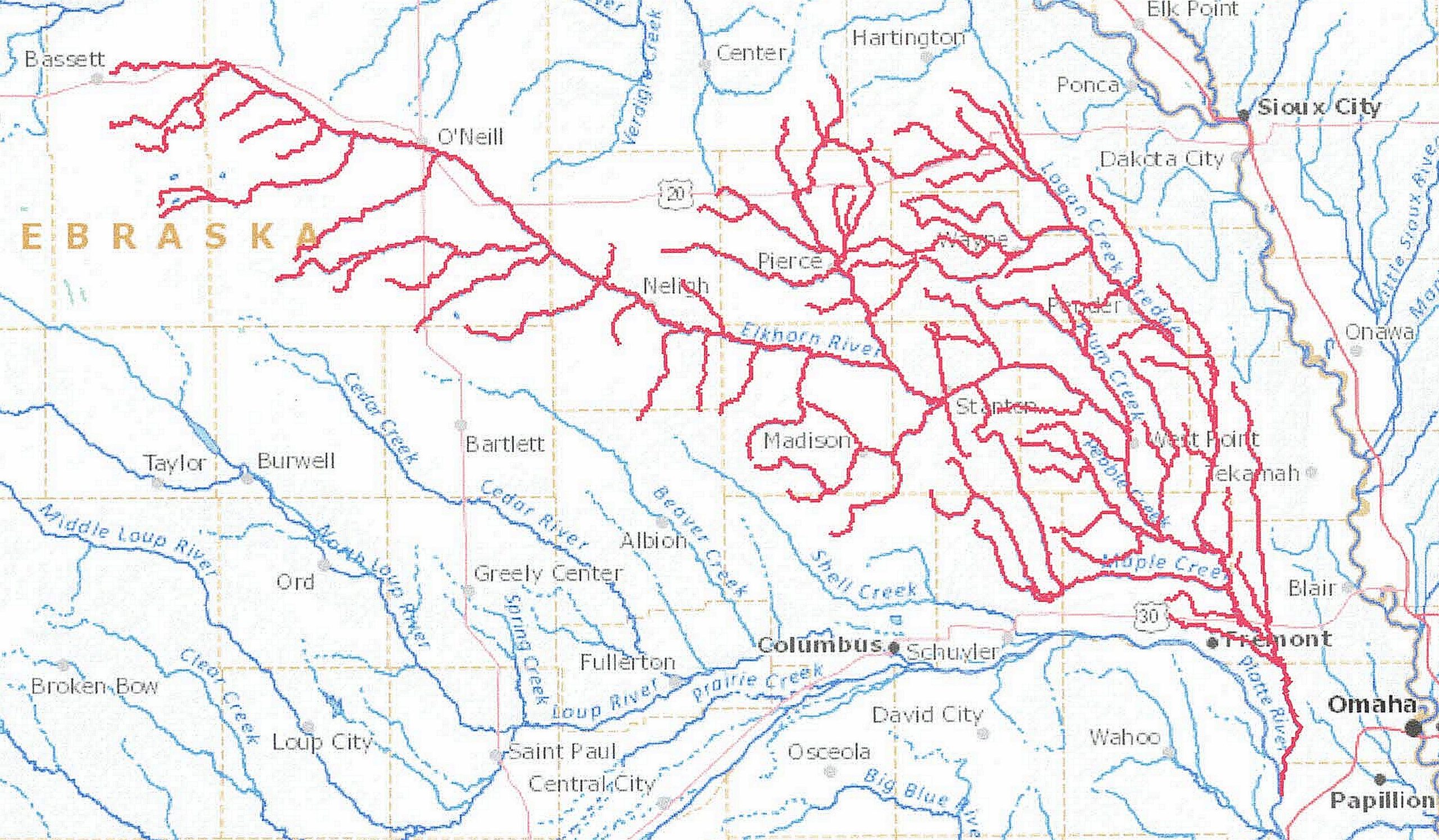
The Elkhorn River drainage system is in northeast Nebraska. The headwaters of the Elkhorn are in the eastern Sandhills near Bassett, Neb. The Missouri River forms the state’s eastern boundary with South Dakota, Iowa, and Missouri. The Missouri River boundary starts approximately 13 miles northeast of Spencer, Neb., ending seven miles southeast of Rulo, Neb. Numerous small creeks from the Missouri River Tributaries Basin drain into the Missouri River.
Many creeks feed the Elkhorn, including Maple Creek and Logan Creek Dredge. The river flows for approximately 290 miles and joins the Platte River west of Gretna, Neb. The river has an average discharge of 1,523 cubic feet per second at the confluence with the Platte River. The Elkhorn River is one of the larger tributaries to the Platte River and serves as a recreational site for boating and fishing.
The flour mill located in Neligh was constructed in 1873 and used water from the Elkhorn River for power. The mill operated for over seventy-five years using locally grown grain ground into flour and, during World War I, also produced corn meal. The flour was sold to the government and for overseas export. A flood in 1920 broke the diversion dam for the mill, forcing the mill to convert to electrical power. The mill closed in 1969 and is a Nebraska State Historical site, a symbol of agricultural history for the state, and on the National Register of Historic Places.
Primary crops grown in these drainages include corn, soybeans, alfalfa, forages, and small grains.
Rivers in Nebraska have flooded over the years, and none more damaging than the historic flood in the spring of 2019. The Missouri, Platte, Elkhorn, Niobrara, and Loup Rivers were all part of that flood. Major floods of record on the Missouri River occurred in 1881, 1943, 1967, 1978, and 1993. Six dams have been constructed on the Missouri River by the United States Army Corps of Engineers to help mitigate flooding along the river. The Missouri River also served as the main path of travel east of the continental divide for the Lewis and Clark Corps of Discovery Expedition of 1804-1806.
Nebraska has an “island” on the Missouri side of the river. McKissick Island is part of Nebraska, but a flood cut the land off from Nebraska, putting it on the Missouri side of the river. The state of Missouri claimed 5,000 acres. But a survey in 1999 firmly placed the land in question in Nebraska, and President Clinton signed the Missouri-Nebraska Boundary Compact into law. The “island” is three miles northeast of Peru, Neb.
Four Natural Resource Districts combine to cover most of these drainages. They are the Papio-Missouri, Lewis & Clark, Lower Elkhorn, and Upper Elkhorn NRDs. The total area is 10,214 square miles. The Lower Niobrara, Lower Platte South, and Nemaha NRDs cover the Missouri River Tributaries Basin. The respective NRDs manage the groundwater in their district.
To view these river drainages and others across the United States, the United States Geological Survey (USGS) has a great website called Streamer (https://txpub.usgs.gov/DSS/streamer/web/) At the website, click “Go to Map.” From the new page, zoom in on the state. In the upper right corner of the page, click “Trace Upstream.” Zoom in and find the point you want to trace the river/stream upstream. To see the Elkhorn River Drainage, click on the river at the confluence with the Platte River between Lincoln and Omaha. If you know the river/stream headwaters/source, you can also use the “Trace Downstream” feature.
The Missouri-Nebraska Boundary Compact can be viewed at https://apps.csg.org/ncic/PDF/Missouri-Nebraska%20Boundary%20Compact.pdf